ABB’s Satellite-Based Technologies Develop More Precise Measurement of Emissions and Earth Changes
April 10, 2026
By Krystie Johnston
One of the biggest challenges in the fight to address climate change is to accurately measure the emissions we produce and the impacts they have on the planet. Although tools and instruments have been useful to identify and measure these variables here on earth, some of the greatest advances in the area involve satellite-based technologies. These specialized instruments like spectrometers made at ABB’s Measurement & Analytics Division in Quebec City Canada, are revolutionizing the way we detect and measure these emissions and their effects.
Sensitive instruments to measure spectral components
Frederic Grandmont has been with ABB’s Measurement & Analytics Division for almost 30 years. A physicist and engineer, he completed his PhD in astronomy instrumentation in collaboration with ABB and has continued his career with them ever since. “Traditionally, we are a company that specializes in spectrometers. A spectrometer is an instrument that analyzes the energy of light in its various colours, like the human [eye, but with much more accuracy].” And these instruments are having a profound impact on our understanding of greenhouse gas emissions.
When you look at a rainbow, you can differentiate five, six, seven, or maybe eight different colours. But spectrometers can go much deeper than this. In the same colour set, they might be able to distinguish thousands – or hundreds of thousand different colours, Grandmont explains, “And when you get to that level of precision, magic happens as you start seeing the fingerprint of matter which this light interacted with! Each atom or molecule constituting matter interacts in very predictable ways with light which leaves very fine colour absorption patterns that are not noticeable when you can only differentiate five or six colours.”
“But ‘stretching’ the rainbow to thousands of colours, makes it obvious to our spectroscopist detective deducing what the light bounced on or transmitted through, before reaching our eyes, or our instrument. And that is a very powerful sensing tool.”
Imaging technology that can stand up in space
Measuring the way light interacts is one part of this story. ABB also developed imagery instrumentation able to superpose such matter detection to a scene in order to create concentration maps for any molecules of interest, the holy grail of invisible gas cloud detection. The interest in bringing these sensors in space follows through naturally. Yet the other part of this story, and equally challenging, is adapting this technology for the harsh space environment.
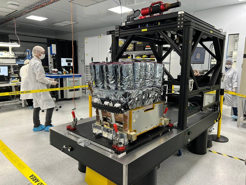
“We designed a new kind of space camera composed of 16 sub-cameras like that on modern phones. The sub-cameras mix resolution and colour set to yield a revolutionary view of the earth down below. In the last five years, we have perfected more and more our imaging technologies which nicely supplement our historical expertise in spectroscopy.”
Grandmont adds, “For years we have built landmark instruments that read the matter, the spectrum. We notably built the spectrometer which holds the record for the highest information content in space since 23 straight years. It is called the ‘SciSat-FTS.’ But in terms of imagery, our biggest innovations are just starting to launch”
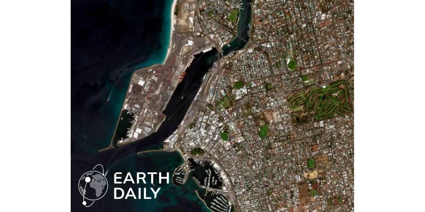
These innovations made headlines recently when EarthDaily, ABB’s customer, released their first high-precision images to the public. These early images from ABB’s multispectral imaging system onboard EarthDaily’s satellite revealed its unique capabilities publicly for the first time. In fact, this system is another record holder in orbit as it can digitize more than 20 billion pixels per second, making it one of the most powerful cameras in orbit. Ever.
Applications that are out of this world
“What we did with EarthDaily, this company based out of Vancouver, [is helping them achieve their aim] of making a 5-meter resolution, 22 colour digital model of the Earth’s surface that gets refreshed every day,” explains Grandmont. Although there are satellites already in orbit able to show us what is happening on Earth, they are quite far from having the capacity to map the entire earth every day.
“The ability to have a refreshed view of the Earth, down to 5 meters in this case, every day is something revolutionary that AI detection algorithms will love to chew on! This is set to transform how space information gets down to us.”
Grandmont adds, “What Earth Daily is bringing in terms of new information is something that is bound to slowly percolate down to our daily lives and change it forever. The future is only made of more frequent, more precise measurement like this.”
He says this is just the first step.
“Refreshing every day, every five meters, required more than 160 cameras working as one in space which produces a lot of information. Next time EarthDaily comes to us to refresh their space asset the question will be:
“Could we go down to higher resolutions, say one meter? and refresh twice or three times per day, maybe hourly,” that sort of thing. This is inevitably where the field is heading in the long run.”
Solving engineering challenges
This accomplishment is easier to appreciate with a closer look at the numbers. “What people do not necessarily realize is that imaging the whole Earth at five meters every day, takes a lot of images, we are talking 10s of millions each day.”
“If you tried to use your phone to do this, you would quickly fill up your phone capacity. ” And you would have to take these pictures at a rate your phone can’t reach. “The speed at which we take images in orbit is very, very high, because the satellite flies at seven kilometers per second. The laws of physics dictate that. We cannot fly slower unfortunately, otherwise we will fall back to earth. In one-second, the earth below will have moved of 7 thousand meters, and you are trying to picture a five-meter still pixel. We are thus talking about thousands of frames per second while modern phones typically top at 60.”
Another engineering challenge is getting these images back down from the satellite. “The satellite has a communication link to the ground for downloading images about once or twice per orbit, and the orbit is an hour and a half. So, you have to accumulate images, and once you fly over a download site, then you transfer as much as you can in a couple minutes. So, we try to compress this information content as much as possible. That part was done by a partner company in Montreal, Xiphos.” Grandmont says there are several partners involved in this marvel, each sharing a portion of the design challenge to make the whole system outperform in orbit.
ABB – Engineered to Outrun
For more than 140 years, ABB has been a global technology leader in electrification and automation with multiple divisions, like their Measurement & Analytics Division, where Grandmont works, that provides world-class measurement solutions for any industry. Space applications, both public and private, hold enormously exciting potential for instrumentation like ABB’s spectrometers and specialized cameras. “Our expertise in spectroscopy, led us to be called on by big space companies internationally…to help them achieve high-end instruments requested by their home governments. We have had a footprint in space for over 30 years helping customers around the world develop innovative instruments.”
Grandmont says there is enormous potential for ABB’s measurement solutions in the space industry. One example is GHGSat offering of precise measurement of greenhouse gas emissions from industrial sites or communities. Another could be to monitor surface changes on Earth. The common dementor is the need for accurate measurement – which is what ABB offers. “We do not sell the data. Our group only builds the instrument or sensor that the customer wants to have. And usually, the customer wants something that nobody else has. So, every time, it is like completely new engineering tailored to that specific customer’s goal.”
Closing thoughts
Use cases that have been publicized include EarthDaily, whose aim is a digitalized model of the earth, or GHGSat who is already actively selling emission monitoring services to industrial customers. “There are all kinds of business cases that stem from a capacity like that [to accurately measure], that did not exist before. And that is what excites the investor to some extent.” Satellite technologies like the imagery and analysis instruments from ABB provide irrefutable data that can be used for these applications, with more applications to come as they evolve to meet the needs of an ever-changing world.
More Information
Related Story
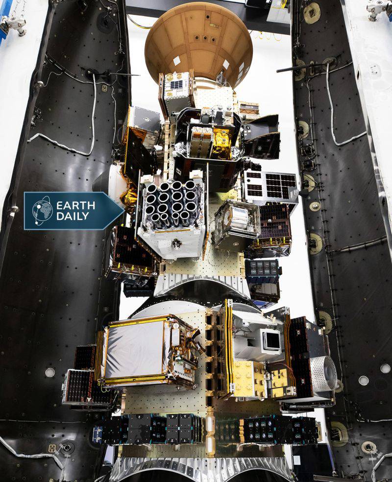
ABB’s Advanced Space Technology Shines as EarthDaily Releases First High‑Precision Images
Canadian geospatial solutions company EarthDaily made an initial public release of processed images from its first satellite, EDC-01. Developed by ABB in close proximity with EarthDaily’s team, the multispectral imaging payload started delivering images in 2025. EarthDaily’s proprietary advanced image fusion algorithms reveal high-precision Earth surface details from various locations. The payload has one of the highest pixel processing capacities in orbit with over 20 billion pixels digitized every second.